Local Government
Chapman Valley
Region
Midwest

Lot 1157 North West Coastal Hwy Howatharra
Lot 1157 Part Lot 30; Plan 30P28842
Howatharra Staging Post
Chapman Valley
Midwest
Constructed from 1860
| Type | Status | Date | Documents |
|---|---|---|---|
| State Register | Registered | 22 Nov 2005 | HCWebsite.Listing+ListingDocument, HCWebsite.Listing+ListingDocument |
| Type | Status | Date | Documents |
|---|---|---|---|
| (no listings) |
| Type | Status | Date | Grading/Management | |
|---|---|---|---|---|
| Category | ||||
| Municipal Inventory | Adopted | 17 Oct 2012 | Category 1 | |
| Aboriginal Heritage Sites Register | Permanent | |||
Cuddy Cuddy Changing Station, Howatharra, has suffered a good deal of damage. Many of the buildings have not been used for a substantial period of time and others have simply been used for storage. The form of construction with stone laid in pug, and the primitively constructed timber roof framing that has resulted in outward thrust on walls, has left some of the buildings in a very poor state. Overall the place is in fair to poor condition.
| Library Id | Title | Medium | Year Of Publication |
|---|---|---|---|
| 7644 | Cuddy Cuddy buildings, conservation works : final conservation works report - grant allocation No 195/534 2004/2005. | Conservation works report | 2006 |
| 9635 | Cuddy Cuddy buildings 4 & 5. | Conservation works report | 2010 |
| 9266 | Cuddy Cuddy buildings, conservation works. | Conservation works report | 2009 |
| 9128 | Cuddy Cuddy buildings, conservation works. | Conservation works report | 2008 |
| 5665 | Cuddy Cuddy Changing Station, Howatharra : conservation plan. | Heritage Study {Cons'n Plan} | 2002 |
Individual Building or Group
| Epoch | General | Specific |
|---|---|---|
| Original Use | MINING | Other |
| Style |
|---|
| Victorian Georgian |
| Vernacular |
| Type | General | Specific |
|---|---|---|
| Wall | STONE | Other Stone |
| Wall | STONE | Granite |
| General | Specific |
|---|---|
| PEOPLE | Early settlers |
| DEMOGRAPHIC SETTLEMENT & MOBILITY | Workers {incl. Aboriginal, convict} |
| OCCUPATIONS | Mining {incl. mineral processing} |
| DEMOGRAPHIC SETTLEMENT & MOBILITY | Resource exploitation & depletion |
| OUTSIDE INFLUENCES | Water, power, major t'port routes |
| OCCUPATIONS | Grazing, pastoralism & dairying |
| TRANSPORT & COMMUNICATIONS | Road transport |
This information is provided voluntarily as a public service. The information provided is made available in good faith and is derived from sources believed to be reliable and accurate. However, the information is provided solely on the basis that readers will be responsible for making their own assessment of the matters discussed herein and are advised to verify all relevant representations, statements and information.
Constructed from 1860
The Cuddy Cuddy Changing Station has considerable historic significance for the important role it played in road transport between the mines at Northampton and the port at Geraldton in the 19th Century prior to the opening of the railway in 1879. The rare group of intact and largely restored buildings presents as a fine collection of simple vernacular rural stone buildings and have been identified as having significance to the State. The place is an important element in a distinctive cultural landscape set against the natural backdrop of Table Hill.
The historic Cuddy Cuddy Changing Station is located on the eastern side of the North West Coastal Highway just to the north of Howatharra. The collection of vernacular stone buildings includes the Homestead, Engine Shed, Long Stables, Small Stables, Large Barn and Cow Shed (shearing shed), which are organised around a lead-in drive and turning circle and set in surrounding paddocks. The outbuildings demonstrate fine stonework with large quoins and finely jointed random-rubble work laid in pug and finished with lime mortar joints. They have a combination of hipped and gabled corrugated iron roofs which have recently been reclad. The Homestead is of stone construction with a hipped corrugated iron roof which extends broken back to cover enclosed verandahs.
Cuddy Cuddy Changing Station was constructed in the c1860s as a staging post for horse teams carting ore from the mines on the Northampton Mineral Field to the port at Champion Bay. The property was owned and occupied by the family of teamster and farmer William Taylor, who worked the property between the 1860s and 1953, with most of the buildings constructed for Taylor in the 1860s. The changing station probably operated for around twenty years, until the railway (b 1879) took over as the main form of transport between Champion Bay and the mines.
Integrity: Medium Original Fabric: Fair Modifications: Restoration works ongoing
Good
| Ref ID No | Ref Name | Ref Source | Ref Date |
|---|---|---|---|
| HCWA- P15838 | "State register Documentation". | ||
| Considine & Griffiths Architects with Robin Chinnery, Historian,; onservation Plan.". | Considine & Griffiths | 2002 |
| Owner | Category |
|---|---|
| Department for Planning and Infrastructure | State Gov't |
This information is provided voluntarily as a public service. The information provided is made available in good faith and is derived from sources believed to be reliable and accurate. However, the information is provided solely on the basis that readers will be responsible for making their own assessment of the matters discussed herein and are advised to verify all relevant representations, statements and information.
2445 Chapman Valley Rd Nanson
Lot 112 on DP 159252
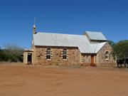
School-Church of Our Lady of Fatima
Chapman Valley
Midwest
| Type | Status | Date | Documents |
|---|---|---|---|
| (no listings) |
| Type | Status | Date | Documents |
|---|---|---|---|
| (no listings) |
| Type | Status | Date | Grading/Management | |
|---|---|---|---|---|
| Category | ||||
| Municipal Inventory | Adopted | 17 Oct 2012 | Category 1 | |
00473 Convent and School-Church of Our Lady of Fatima, Nanson
Individual Building or Group
| Epoch | General | Specific |
|---|---|---|
| Present Use | RELIGIOUS | Church, Cathedral or Chapel |
| Original Use | RELIGIOUS | Church, Cathedral or Chapel |
| Type | General | Specific |
|---|---|---|
| Wall | STONE | Local Stone |
| Roof | METAL | Corrugated Iron |
| General | Specific |
|---|---|
| SOCIAL & CIVIC ACTIVITIES | Religion |
This information is provided voluntarily as a public service. The information provided is made available in good faith and is derived from sources believed to be reliable and accurate. However, the information is provided solely on the basis that readers will be responsible for making their own assessment of the matters discussed herein and are advised to verify all relevant representations, statements and information.
Constructed from 1938
The Church of Our Lady of Fatima has very high historic significance for its connection with the provision of much needed educational services by the Presentation Sisters to the local Catholic community, and later as a church for religious services. The Church-School and adjacent Convent have further historic value for their close association with renowned Priest-Architect Monsignor John Hawes, who designed both buildings, and local builder Enrico Boschetti, who constructed them. The church building has considerable aesthetic value as a fine Inter-War Romanesque style stone building characterised by its robust form and decorative detailing. Together with the nearby Anglican Church, the buildings combine to form a pleasing cultural environment.
Located south of the town of Nanson and adjacent to the former Convent, the Church of Our Lady of Fatima is of local stone construction designed in the Inter-War Romanesque style. The building has coursed rubble stone walls with matching mortar, and a combination of brick and concrete quoining to openings. A simple bellcote and cross adorn the east gable wall, which also features a large round window and a projecting entry portico below. The gable roof is timber framed and clad with corrugated iron. Matching and very sympathetic extensions by architects Summerhayes and Associates, carried out in the 1950s, extend to the west. Unsympathetic aluminium windows, with coloured glass to the lower panes, have replaced the original timber windows in the main body of the church. A small marble foundation stone is set into the east wall of the projecting entry portico, and reads “This stone was blessed and laid by the Most Rev. James P. O’Collins D.D. Bishop of Geraldton 29. Jan. 1939.” Internally the church still contains the church pews which adapted for use as school desks.
In the late 1930s there were a significant number of Catholic school-aged children living in the Nanson locale to warrant consideration of a school. In 1936, Reserve 21544 was gazetted as a Reserve and vested in the Geraldton Diocese. In early 1938, renowned Priest-Architect Monsignor John Hawes drew up plans for a school building, and the foundation stone for the building was laid by the Bishop of Geraldton, James Patrick O’Collins, on Sunday 13 November 1938. The stone school building was constructed by builder Enrico (‘Henry’) Boschetti for approximately 650 pounds. The building was officially blessed and opened by Dr J.P. O'Collins on 29 January 1939. Three Presentation Sisters from the Northampton Convent arrived to live in the adjacent Convent and teach at the new school. In the early 1950s, the Nanson school was modified for use as a church, with the sympathetic addition of a sanctuary and sacristy extending out from the western facade, designed by Summerhayes & Associates. When classes were held, the church seating was converted into desks and then changed back again for Sunday Mass. Approximately 30-40 students attended the school at this time. Following a decline in the local population the Presentation Sisters were forced into closing the school in 1965. The church is still used on a regular basis with services conducted by the Northampton Priest. The Church and Convent are included on the Shire of Chapman Valley’s Heritage Trail.
Integrity: High Original Fabric: Predominately Intact Modifications: Large addition to west
Good
| Name | Type | Year From | Year To |
|---|---|---|---|
| Monsignor John Hawes | Architect | 1938 | - |
| Ref ID No | Ref Name | Ref Source | Ref Date |
|---|---|---|---|
| Taylor J : "Conservation Plan for Our Lady of Fatima Church and Convent, Nanson". | 2000 | ||
| HCWA P473 | "Register Assessment Documentation". | HCWA | |
| Marchant JR; "Cork to Capricorn: A History of the Presentation Sisters in Western Australia 1891 – 1991". | Perth | 1996 | |
| Chapman Valley Heritage Trail Brochure, | 1988 | ||
| "The Record" p. 8 | 23/2/1939 | ||
| Taylor J; "Between Devotion and Design: The Architecture of John Cyril Hawes 1876-1956". | UWA Press | 2000 |
| Owner | Category |
|---|---|
| Roman Catholic Church Diocese of Geraldton | Church Property |
This information is provided voluntarily as a public service. The information provided is made available in good faith and is derived from sources believed to be reliable and accurate. However, the information is provided solely on the basis that readers will be responsible for making their own assessment of the matters discussed herein and are advised to verify all relevant representations, statements and information.
Lot 111 Chapman Valley Rd Nanson
Address also includes 2445 Chapman Valley Rd (pt Lot 112); Lot 111 Reserve R21544
Nanson Convent
Our Lady of Fatima Convent
Chapman Valley
Midwest
Constructed from 1938
| Type | Status | Date | Documents |
|---|---|---|---|
| State Register | Registered | 14 Mar 2008 | HCWebsite.Listing+ListingDocument, HCWebsite.Listing+ListingDocument |
| Type | Status | Date | Documents |
|---|---|---|---|
| (no listings) |
| Type | Status | Date | Grading/Management | |
|---|---|---|---|---|
| Category | ||||
| Register of the National Estate | Indicative Place | |||
| Classified by the National Trust | Recorded | 27 May 1974 | ||
| Aboriginal Heritage Sites Register | Adopted | |||
| Municipal Inventory | Adopted | 17 Oct 2012 | Category 1 | |
Generally in good condition and has been well maintained, although some unsympathetic repairs have been carried out to cracks in the stonework of the school-church building using cement rich mortar.
| Name | Type | Year From | Year To |
|---|---|---|---|
| Monsignor John Hawes | Architect | - | - |
| Summerhayes & Assoc (1950s addition) | Architect | - | - |
Individual Building or Group
| Epoch | General | Specific |
|---|---|---|
| Present Use | RELIGIOUS | Church, Cathedral or Chapel |
| Original Use | RELIGIOUS | Church, Cathedral or Chapel |
| Style |
|---|
| Inter-War Romanesque |
| Type | General | Specific |
|---|---|---|
| Roof | METAL | Corrugated Iron |
| Wall | STONE | Local Stone |
| General | Specific |
|---|---|
| PEOPLE | Famous & infamous people |
| SOCIAL & CIVIC ACTIVITIES | Religion |
| SOCIAL & CIVIC ACTIVITIES | Education & science |
This information is provided voluntarily as a public service. The information provided is made available in good faith and is derived from sources believed to be reliable and accurate. However, the information is provided solely on the basis that readers will be responsible for making their own assessment of the matters discussed herein and are advised to verify all relevant representations, statements and information.
The Nanson Convent has considerable historic significance for its connection with the adjacent church-school which provided for much needed educational services to the local community. The Convent and Church-School have further historic value for their close association with renowned Priest-Architect Monsignor John Hawes, who designed both buildings, and local builder Enrico Boschetti, who constructed them. The place has considerable aesthetic merit for its fine use of local stone and decorative detailing including brick quoining and bay window. Together with the nearby Anglican Church, the buildings combine to form a pleasing cultural environment.
Located immediately to the south of the Church of Our Lady of Fatima, the former convent is situated in an enclosed garden with a pathway leading from the gate to the main entrance. The single storey building is constructed of locally quarried stone with a hipped corrugated iron roof. The roof features simple ventilation gablets and is punctuated by a tall masonry chimney to the northwest roofscape. The roof extends broken back to cover the surrounding verandahs which are supported on square timber posts and partly enclosed with shade cloth. Brick quoining enhances the corners and openings while a bay window to the eastern facade is where the chapel is located. Windows are timber framed double hung and multi pane in style with rendered sills. (Refer to HCWA RHP Documentation for a more detailed description including internal description.)
The Convent, designed by Monsignor Hawes, was built by Enrico (‘Henry’) Boschetti in 1938 at a cost of 700 pounds. Both the convent and the adjacent church school building were opened and blessed by the Bishop of Geraldton, the Most Reverend Dr O'Collins on 29 January 1939. To begin with three Presentation Sisters, who had been transferred from the Northampton Convent, were in residence at the Nanson convent and taught at the adjacent school. From the late 1950s enrolments at the adjacent church school began to decline resulting in the closure of both the school and the convent in 1965. At present the former convent functions as a private residence. (Source: HCWA RHP Documentation)
High
Good
This information is provided voluntarily as a public service. The information provided is made available in good faith and is derived from sources believed to be reliable and accurate. However, the information is provided solely on the basis that readers will be responsible for making their own assessment of the matters discussed herein and are advised to verify all relevant representations, statements and information.
Lot 111 Chapman Valley Rd Nanson
Lot/Loc: 111 DiagPlan: 159252 Vol 3141 Fol 989
Chapman Valley
Midwest
| Type | Status | Date | Documents |
|---|---|---|---|
| (no listings) |
| Type | Status | Date | Documents |
|---|---|---|---|
| (no listings) |
| Type | Status | Date | Grading/Management | |
|---|---|---|---|---|
| Category | ||||
| Municipal Inventory | Adopted | 31 Oct 1996 | Category 1 | |
00473 Convent and School-Church of Our Lady of Fatima, Nanson
Individual Building or Group
| Epoch | General | Specific |
|---|---|---|
| Present Use | RESIDENTIAL | Single storey residence |
| Original Use | RELIGIOUS | Monastery or Convent |
| Type | General | Specific |
|---|---|---|
| Wall | STONE | Local Stone |
| Roof | METAL | Corrugated Iron |
| General | Specific |
|---|---|
| SOCIAL & CIVIC ACTIVITIES | Religion |
This information is provided voluntarily as a public service. The information provided is made available in good faith and is derived from sources believed to be reliable and accurate. However, the information is provided solely on the basis that readers will be responsible for making their own assessment of the matters discussed herein and are advised to verify all relevant representations, statements and information.
Constructed from 1938
The Nanson Convent has considerable historic significance for its connection with the adjacent church-school which provided for much needed educational services to the local community. The Convent and Church-School have further historic value for their close association with renowned Priest-Architect Monsignor John Hawes, who designed both buildings, and local builder Enrico Boschetti, who constructed them. The place has considerable aesthetic merit for its fine use of local stone and decorative detailing including brick quoining and bay window. Together with the nearby Anglican Church, the buildings combine to form a pleasing cultural environment.
Located immediately to the south of the Church of Our Lady of Fatima, the former convent is situated in an enclosed garden with a pathway leading from the gate to the main entrance. The single storey building is constructed of locally quarried stone with a hipped corrugated iron roof. The roof features simple ventilation gablets and is punctuated by a tall masonry chimney to the northwest roofscape. The roof extends broken back to cover the surrounding verandahs which are supported on square timber posts and partly enclosed with shade cloth. Brick quoining enhances the corners and openings while a bay window to the eastern facade is where the chapel is located. Windows are timber framed double hung and multi pane in style with rendered sills. (Refer to HCWA RHP Documentation for a more detailed description including internal description.)
The Convent, designed by Monsignor Hawes, was built by Enrico (‘Henry’) Boschetti in 1938 at a cost of 700 pounds. Both the convent and the adjacent church school building were opened and blessed by the Bishop of Geraldton, the Most Reverend Dr O'Collins on 29 January 1939. To begin with three Presentation Sisters, who had been transferred from the Northampton Convent, were in residence at the Nanson convent and taught at the adjacent school. From the late 1950s enrolments at the adjacent church school began to decline resulting in the closure of both the school and the convent in 1965. At present the former convent functions as a private residence. (Source: HCWA RHP Documentation)
Integrity: High Original Fabric: Predominantly Intact Modifications: Some verandah infill
Good
| Name | Type | Year From | Year To |
|---|---|---|---|
| Monsignor John Hawes | Architect | 1938 | - |
| Ref ID No | Ref Name | Ref Source | Ref Date |
|---|---|---|---|
| Taylor J : "Conservation Plan for Our Lady of Fatima Church and Convent, Nanson". | 2000 | ||
| Marchant JR; "Cork to Capricorn: A History of the Presentation Sisters in Western Australia 1891 – 1991". | Perth | 1996 | |
| "The Record" p. 8 | 23/2/1939 | ||
| Chapman Valley Heritage Trail Brochure, | 1988 | ||
| Taylor J; "Between Devotion and Design: The Architecture of John Cyril Hawes 1876-1956". | UWA Press | 2000 | |
| HCWA P473 | "Register Assessment Documentation". | HCWA |
This information is provided voluntarily as a public service. The information provided is made available in good faith and is derived from sources believed to be reliable and accurate. However, the information is provided solely on the basis that readers will be responsible for making their own assessment of the matters discussed herein and are advised to verify all relevant representations, statements and information.

13 East Tce Nanson
HCWA PLAQUE; Lot 15 Reserve R13226
Nanson Roads Board Hall
Nanson Roads Board Office
Chapman Valley
Midwest
Constructed from 1913 to 1982
| Type | Status | Date | Documents |
|---|---|---|---|
| State Register | Registered | 12 Dec 1997 | HCWebsite.Listing+ListingDocument, HCWebsite.Listing+ListingDocument |
| Type | Status | Date | Documents |
|---|---|---|---|
| (no listings) |
| Type | Status | Date | Grading/Management | |
|---|---|---|---|---|
| Category | ||||
| Register of the National Estate | Nominated | 23 Dec 1982 | ||
| Register of the National Estate | Indicative Place | |||
| Classified by the National Trust | Classified | 06 Sep 1982 | ||
| Municipal Inventory | Adopted | 17 Oct 2012 | Category 1 | |
| Library Id | Title | Medium | Year Of Publication |
|---|---|---|---|
| 4280 | Pressed Metal Ceiling Preservation, Restoration and Painting Former Roads Board Building Nanson, WA-Final Report | Report | 2000 |
| 3533 | Roofing and Maintenance Items Former Roads Board Building, Nanson, Western Australia | Heritage Study {Other} | 1998 |
| 7954 | Proposed restoration works to the former roads board building Nanson Western Australia. | Conservation works report | 2006 |
| 2922 | Former Roads Board Building Nanson WA conservation plan | Heritage Study {Cons'n Plan} | 1997 |
Individual Building or Group
| Epoch | General | Specific |
|---|---|---|
| Present Use | SOCIAL\RECREATIONAL | CWA Hall |
| Original Use | GOVERNMENTAL | Town, Shire or District Hall |
| Style |
|---|
| Federation Free Style |
| Type | General | Specific |
|---|---|---|
| Wall | BRICK | Common Brick |
| Roof | METAL | Corrugated Iron |
| General | Specific |
|---|---|
| SOCIAL & CIVIC ACTIVITIES | Community services & utilities |
| SOCIAL & CIVIC ACTIVITIES | Government & politics |
This information is provided voluntarily as a public service. The information provided is made available in good faith and is derived from sources believed to be reliable and accurate. However, the information is provided solely on the basis that readers will be responsible for making their own assessment of the matters discussed herein and are advised to verify all relevant representations, statements and information.
Constructed from 1913
The Nanson Roads Board Hall is of considerable historic significance because of its association with local government in the Chapman Valley district for over fifty years. The subsequent use of the place by the CWA and now the Chapman Valley Historical Society and its setting in the Nanson Museum grounds give the place social value. The building is highly valued by the local community. It contributes greatly to the Nanson streetscape.
Located at the centre of the small Nanson townsite, addressing East Terrace, this single storey brick building displays some characteristics of the Federation Free style. The one-roomed rectangular red brick building has a simple roof form with a half-gable behind a triangular pediment in the front facade. Four prominent cylindrical vents and a square brick corbelled chimney penetrate the roofscape. The walls are constructed in stretcher bond brickwork with contrasting bands of stucco applied to the front elevation for decorative purposes. Rendered lintels are evident to all the openings. The words ‘Roads Board’ are inscribed in painted raised lettering within the entablature to the front facade, while the date is contained in the triangular pediment above. Below this are double timber entry doors with timber double hung sash windows either side and to the side elevations. The brickwork to the side walls is painted. Some remnant flashing remains in the rear wall, evidence of an addition since removed (This was the residence for the Shire worker). There is a water tank to the south west corner. Elsewhere on the site is a picturesque pergola and several large sheds comprising the Nanson Museum and the headquarters of the Chapman Valley Historical Society.
The Upper Chapman Roads Board was formed on 16 January 1901. The first permanent Secretary-Supervisor of the Roads Board was Bill Stansfield. In 1910 the railway line reached the district and in October of that year the town of Nanson was gazetted. In 1912, when the growing population of the district required a dedicated Roads Board office, a referendum was held to decide whether it would be sited at Nanson or Nabawa to the north. Nanson won the vote. In 1913, the Nanson Roads Board Hall was built to a Public Works Department plan and financed by a Public Works Department grant of 112 pounds. The tender for the construction of the building was awarded to Mr W. Bennett at a cost of 297 pounds. Bricks used in the construction of the Hall were made in a brick kiln located on the river flat immediately north of the `Glandonne Homestead'. The building was officially opened by the State Governor, Sir Harry Barron. The railway line closed in 1957 following which Nanson lost some of its permanent residents. The following year the Roads Board changed its name to Chapman Valley Roads Board. Meanwhile Nabawa had grown in size and population and was regarded as better suited for the new Shire Offices which opened in 1964; the Roads Board having become the Shire of Chapman Valley on 1 July 1961. Following the closure of the Nanson Roads Board Hall in 1964, the building was then used by the Country Women's Association as a meeting place until 1974. Having fallen into disuse and disrepair, the building was restored in 1983 by the Chapman Valley Historical Society. A small cottage which housed the Road Board Caretaker is located to the rear of the property and was restored in 2010.
Integrity: High Original Fabric: Predominantly Intact Modifications: Painted brickwork
Good
| Name | Type | Year From | Year To |
|---|---|---|---|
| Public Works Department | Architect | 1913 | - |
| Ref ID No | Ref Name | Ref Source | Ref Date |
|---|---|---|---|
| HCWA P474 | "Registration Documentation". | HCWA | |
| Chapman Valley Heritage Trail Brochure, | 1988 | ||
| c | |||
| Griffiths, P; "Conservation Plan for the Nanson Roads Board Hall." | Considine & Griffiths Pty Ltd |
| Owner | Category |
|---|---|
| Shire of Chapman Valley | Local Gov't |
This information is provided voluntarily as a public service. The information provided is made available in good faith and is derived from sources believed to be reliable and accurate. However, the information is provided solely on the basis that readers will be responsible for making their own assessment of the matters discussed herein and are advised to verify all relevant representations, statements and information.
The Road Board Office is the only public building of significant character left in the Chapman valley area. Fettlers cottages in the same street are a reminder that the small community was formed to serve the railway between Geraldton and Yuna, whichclosed in 1956. Most of the railway workeres were then transferred and the cottages fell into disrepair through some are still occupied. It was used for Road Board meetings until 1963 but continued to serve for ten years as a meeting hall for local organisations and a centre for bush fire control, using a hand-rung telephone switchboard. The intention is for the local Historical Society to restore the building to become a museum, using the outside yard for relics of farm equipment.
Brick, iron roof. Built in 1913 of locally made red brick. tick pointed. Cement window copings and gable parapet with inset description (1913) are characteristic of the buildings of that period. The roof is high pitched corrugated iron; the ceilings of crimped metal sheets and the timber floor are both in good condition. There is evidence of a rear room having been demolished.
Assessment 1982 Built 1913
This information is provided voluntarily as a public service. The information provided is made available in good faith and is derived from sources believed to be reliable and accurate. However, the information is provided solely on the basis that readers will be responsible for making their own assessment of the matters discussed herein and are advised to verify all relevant representations, statements and information.
Lot 11 Narra Tarra Rd Narra Tarra
Diagram/Plan: P232393/2 Volume/Folio: Vol 2047 Fol 248
Chapman Valley
Midwest
| Type | Status | Date | Documents |
|---|---|---|---|
| (no listings) |
| Type | Status | Date | Documents |
|---|---|---|---|
| (no listings) |
| Type | Status | Date | Grading/Management | |
|---|---|---|---|---|
| Category | ||||
| Municipal Inventory | Adopted | 31 Oct 1996 | Category 1 | |
06353 Narra Tarra Homestead, Outbuildings & Cemetery
Individual Building or Group
| Epoch | General | Specific |
|---|---|---|
| Original Use | FARMING\PASTORAL | Homestead |
| Type | General | Specific |
|---|---|---|
| Wall | STONE | Local Stone |
| Roof | METAL | Corrugated Iron |
| Wall | BRICK | Other Brick |
| Roof | TILE | Other Tile |
| General | Specific |
|---|---|
| PEOPLE | Local heroes & battlers |
This information is provided voluntarily as a public service. The information provided is made available in good faith and is derived from sources believed to be reliable and accurate. However, the information is provided solely on the basis that readers will be responsible for making their own assessment of the matters discussed herein and are advised to verify all relevant representations, statements and information.
Constructed from 1853
The Narra Tarra Homestead and Outbuildings have considerable historic significance as one of the five original pastoral leases in the district. The place has further historic value for its close association with three generations of the family of Joseph Green and John Mills. The property and its various buildings and structures, including the cemetery, is indicative of the large pastoral leases of the 1850s and 1860s preceding the closer agricultural settlement at the turn of the century. Narra Tarra Homestead and Outbuildings has aesthetic value for its picturesque setting, use of local stone and high integrity. This is a fairly complete collection of buildings which illustrates the varied aspects of the running of homestead pastoral properties and the transition to agricultural use.
The Narra Tarra Homestead Precinct includes the stone ruins of the original homestead, the current homestead, a series of outbuildings (kitchen/dining building, store/workers' quarters, ruins of dairy and creamery) and a shearing shed. Some outbuildings have been demolished or have fallen down. Remnant ruins of an old shepherd's hut are situated near the shearing shed. Stone ruins of the original homestead are located on low ground to the west of the current house closer to the East Chapman River, which was flood prone. A small walled cemetery is located on Victoria Location 873, to the north east of the Homestead Precinct but is owned separately and is actually located within the City of Geraldton-Greenough’s municipal boundaries. Homestead: Set in an elevated location the building is surrounded by gardens and a steel post and mesh fence and the adjacent is the Kitchen/Dining Room building which are connected by covered walkway. The large single storey homestead has been extended and modified over time to accommodate its continued use. The walls of the original section of the homestead are rendered and painted stone, mostly featuring a smooth ashlar finish. Quoining to the corners and around openings has since been rendered. The current hipped concrete tiled roof has replaced earlier pressed tin tiles which in turn replaced a corrugated iron roof prior to that. The roof extends over the verandah to the west elevation and is supported on square timber posts. Old photographs of the homestead reveal that the original roof was constructed of shingles with thatching/rush to the verandahs. The original plan comprised two front rooms and hall with three rooms behind to which the dining room and the current kitchen were added. The current kitchen was a bedroom when first added, as meals were prepared and eaten in the external kitchen. The fire place and chimney were removed from the east end of the front bedroom and additional bedrooms of painted brick construction were later added at the rear. The feature bay windows to the west elevation have tapering walls below sill level and project onto the front verandah, being a later modification. The homestead features a cellar. Kitchen/Dining Room: Located immediately to the rear (east) of the homestead, this tall stone building has a steeply pitched corrugated iron roof, hipped to the north and gabled to the south and punctuated by two corbelled brick chimneys. Red brick quoining to openings has been painted, or lime-washed, over in part. The southern elevation comprises asbestos sheeting to the end wall. Internally some rooms feature boarded timber ceilings. Store/Worker's Quarters: Located to the east of the Kitchen/Dining Room, this stone building has a corrugated iron hipped roof which extends to cover partly enclosed surrounding verandahs supported on timber posts. There is a carport to the southern side. The building features extra wide doorways suggesting some specific use. Shearing Shed: Located to the east of the Homestead Precinct, the original stone building has a corrugated iron roof. Several corrugated iron timber additions have been added to the building over the years and obscure much of the original inner structure, although they are currently in various stages of collapse. A more modern shearing shed is located immediately to the west.
Mr Joseph Green first came to the Victoria District in 1850 as a carter of goods from the Avon and Swan districts. He took up the lease of Narra Tarra, approximately 10 miles from Geraldton adjacent to the junction of the East and Upper Chapman Rivers, where he built a home for his family. The Narra Tarra lease was originally a large holding of 100 000 acres stretching as far as Mt Erin. The property has since been greatly subdivided, the bulk of the subdivision taking place in 1910. Joseph Green's daughter, Caroline, married Mr John Mills in 1857. John Mills was a mounted constable who came to Champion Bay from Essex in 1855. The couple took over from Joseph Green in running Narra Tarra (Their granddaughter, Beryl Mills, became the first Miss Australia in 1926). One of their sons, Frank Mills, carried on managing the property until 1899 when, owing to financial difficulties, he was forced to sell Narra Tarra to Mr Samuel Lockier Burges from Bowes for the sum of 12 000 pounds. Sam Burges, who married Bertha Mills - the daughter of John and Caroline Mills, was the first man in the district to own a car – a 1905 model Ford, and also the first local to own a tractor, a steam Fowler traction engine. Sam Burges, who became a Justice of the Peace, was noted for growing large areas of wheat with the use of machinery. A costly privy Council law suit over Willi Gulli Station near Northampton and expensive living which included the upkeep of a houseboat on the Thames in London are said to have impoverished Burges. Consequently, in 1909 Burges was forced to sell Narra Tarra to the government, after which it was subdivided into blocks of approximately 2,500 acres and sold to the new wave of settlement farmers coming into the district. The new owner of the homestead, now located on Narra Tarra Estate Lot 11, was Mr James Mitchell (later Sir James Mitchell). In 1925 the property came into the hands of Mr Frank Green, a well known merchant and store owner of Geraldton, and his son Eldred. Frank Green endeavoured to repurchase land from the original Narra Tarra lease as surrounding farmers went broke during the depression and other lean periods. The property also included a private cemetery situated on the banks of the East Chapman River. The cemetery contains the graves of several members of the families who at different stages owned the Narra Tarra property. Those buried there include John Mills, buried in 1900, and his infant son (18 months) buried in 1874. A further grave marks the burial place of another infant, Firebrace Darlot, buried in 1888. A `half time' school, named the Narra Tarra School, was opened at the turn of century to compliment the one operating at Nabawa. Although the school has the same name as the pastoral property it was actually located near the Nanson townsite. Incidentally, Narra Tarra is also the name of a mine site situated to the north west of Nanson. This mine is also referred to as the Protheroe Mine after the name of the townsite which emerged there. During World War II there were four Italian prisoners of war, captured in Egypt, sent to work at Narra Tarra. Joshuah Mills, a second son of John Mills, acquired part of the original Narra Tarra lease. In turn, his son J. Stuart Mills, took over the farm and it then operated as J S Mills and Son. The original Narra Tarra lease consisted of undulating countryside, including some first class agricultural land which was ideal for wool growing. Over the years wool (Merino) and cattle (Aberdeen Angus) have been bred on the property. Barley and oats have been grown at times to supplement the low price of wool. The current homestead is actually the second one built on the property. The first homestead, a simple stone cottage situated on the banks of the East Chapman River was flooded. Consequently, a second and more substantial house was built on higher ground. Narra Tarra, an aboriginal word, is widely held to mean `Hill Camp', although it has also been translated as `Where the two waters meet'. Narra Tarra is mentioned in Randolf Stowe's Novel Merry-go-round in the Sea.
Integrity: Medium
| Ref ID No | Ref Name | Ref Source | Ref Date |
|---|---|---|---|
| "Homesteads of the Mid West Region of Western Australia". p.19 | Geraldton Camera Club | 1997 | |
| Thiel PWH & Co; "Twentieth Century Impressions". | Hesperian Press | 1901 | |
| HCWA P6353 | "Registration Documentation". | HCWA | |
| McDonnel PA; "Chapman Valley Pioneers". No. 93 | Geraldton Newspapers, Geraldton | 1974 |
This information is provided voluntarily as a public service. The information provided is made available in good faith and is derived from sources believed to be reliable and accurate. However, the information is provided solely on the basis that readers will be responsible for making their own assessment of the matters discussed herein and are advised to verify all relevant representations, statements and information.

982 Narra Tarra-Moonyoonooka Rd Narra Tarra
Includes two Homesteads, Kitchen Outbuildings, Store, Quarters, Machinery Stores, Shearing Sheds & Cemetery
Chapman Valley
Midwest
Constructed from 1853
| Type | Status | Date | Documents |
|---|---|---|---|
| State Register | Registered | 09 Sep 2003 | HCWebsite.Listing+ListingDocument, HCWebsite.Listing+ListingDocument |
| Type | Status | Date | Documents |
|---|---|---|---|
| (no listings) |
| Type | Status | Date | Grading/Management | |
|---|---|---|---|---|
| Category | ||||
| Municipal Inventory | Adopted | 31 Oct 1996 | ||
| Library Id | Title | Medium | Year Of Publication |
|---|---|---|---|
| 9277 | Conservation plan for Narra Tarra homestead group Howathara Western Australia. | Heritage Study {Cons'n Plan} | 0 |
| 5753 | Homesteads of the mid west region of Western Australia. | Book | 1997 |
Historic site
| Epoch | General | Specific |
|---|---|---|
| Original Use | MONUMENT\CEMETERY | Cemetery |
| Original Use | FARMING\PASTORAL | Homestead |
| Present Use | MONUMENT\CEMETERY | Grave |
| Style |
|---|
| Victorian Georgian |
| Type | General | Specific |
|---|---|---|
| Other | TIMBER | Other Timber |
| Wall | STONE | Local Stone |
| Roof | TILE | Other Tile |
| Roof | METAL | Corrugated Iron |
| General | Specific |
|---|---|
| OCCUPATIONS | Grazing, pastoralism & dairying |
This information is provided voluntarily as a public service. The information provided is made available in good faith and is derived from sources believed to be reliable and accurate. However, the information is provided solely on the basis that readers will be responsible for making their own assessment of the matters discussed herein and are advised to verify all relevant representations, statements and information.

Lot 1455 Chapman Valley Rd Waggrakine
1km north of Nabawa Road. MI states: Coffe Pot Dr
Coffee Plot
Chapman Valley
Midwest
Constructed from 1872
| Type | Status | Date | Documents |
|---|---|---|---|
| State Register | Registered | 20 Jul 2004 | HCWebsite.Listing+ListingDocument, HCWebsite.Listing+ListingDocument |
| Type | Status | Date | Documents |
|---|---|---|---|
| (no listings) |
| Type | Status | Date | Grading/Management | |
|---|---|---|---|---|
| Category | ||||
| Municipal Inventory | Adopted | 17 Oct 2012 | Category 1 | |
| Library Id | Title | Medium | Year Of Publication |
|---|---|---|---|
| 11616 | Coffee Pot & Waggrakine Well: Chapman Valley Road near Coffee Pot Drive Waggrakine, Shire of Chapman Valley WA | Heritage Study {Cons'n Plan} | 2012 |
Individual Building or Group
| Epoch | General | Specific |
|---|---|---|
| Original Use | RESIDENTIAL | Single storey residence |
| Present Use | VACANT\UNUSED | Vacant\Unused |
| Style |
|---|
| Vernacular |
| Type | General | Specific |
|---|---|---|
| Wall | STONE | Other Stone |
| Roof | METAL | Corrugated Iron |
| General | Specific |
|---|---|
| OCCUPATIONS | Rural industry & market gardening |
This information is provided voluntarily as a public service. The information provided is made available in good faith and is derived from sources believed to be reliable and accurate. However, the information is provided solely on the basis that readers will be responsible for making their own assessment of the matters discussed herein and are advised to verify all relevant representations, statements and information.
Constructed from 1872
Coffee Pot and Waggrakine Well has considerable historic significance for its close association with the eccentric pioneer Reverend Charles Grenfell Nicolay, and as a remnant of his ambitious endeavour to establish a coffee plantation in Western Australia. Further, the place is an example of the Colonial Government’s support for experimental crops, in search of revenue for the young colony. The place has landmark value due to its elevated siting, its present lack of surrounding development, together with its distinctive and unusual roof form. Coffee Pot is highly regarded by the local community as evident by their past efforts at restoration of place. Waggrakine Well has historic value as a source of water first surveyed by W. Phelps in 1870.
The remains of a small stone cottage and well are located in a paddock on sloping land approximately 700 metres north of Chapman Valley Road. Access at the time of the assessment was across private land, however the land is subject to a planned residential subdivision. This will result in the cottage and well being located at the end of a culde- sac on a Reserve vested in the Shire of Chapman Valley. The cottage is a rectangular, two-room structure with stone walls and a distinctive steeply pitched pyramid-shaped roof. The roof is clad with wheat coloured colorbond sheets which extends at a lower pitch to cover a room on the west side of the cottage. The random rubble stone walls, approximately 450mm wide, have been laid on a plinth, projecting below floor level. Different hues to the stonework indicate that the lean-to sections of the cottage were added at a different time – with darker stone used on the original central section of the cottage and a lighter pink for the western lean-to and dark stone to the eastern lean-to. The north-east corner of the building has collapsed, with the loose stone remaining on site. Located to the east of the cottage, the well is at ground level with stone walls. The opening is approximately 2.2 metres in diameter, with sheets of corrugated iron placed over the top of the well to provide cover.
The ‘Coffee Pot’, a corruption of ‘Coffee Plot’, is located on the site of an experimental coffee plantation. The plantation was authorised by Governor Weld in July 1870, on the recommendation of Reverend Charles Grenfell Nicolay, who was appointed as Chaplain to Geraldton in 1870. The unnumbered reserve was situated on the western slope of the Moresby Ranges and was comprised of approximately 640 acres. The Government agreed to commit 100 pounds for the project which was used to pay for seed and to employ at least five ticket of leave men between 1870 and 1872. Nicolay and his son, Frederick, planted coffee seeds from Aden and Brazil, as well as several fig trees. A well was also built alongside the cottage as a water supply. By the end of 1873 the experimental coffee plantation had failed due mainly to the persistently strong winds and lack of rainfall, and the reserve was subsequently sold. For many years the land was used to graze sheep and grow wheat while the building fell into ruin. During World War Two the property was used by the army by which time the building had no floors or roof. In later years the building was used as a silo requiring the chimney to be bricked up. In the early 1980s local residents organised the re-roofing of the building to provide some protection from the weather. (Source: HCWA RHP Documentation)
Integrity : Medium
Poor
| Ref ID No | Ref Name | Ref Source | Ref Date |
|---|---|---|---|
| HCWA P475 | "Registration Docuymnetation". | HCWA | |
| Chapman Valley Heritage Trail Brochure | Shireo f Chapman Valley | ||
| Playford PE; "The Reverend C.G. Nicolay: A Pioneer Geographer, Geologist and Museum Curator in WA", Vol 7 No. 1 | Journal of the Royal Western Australian Historical Society, | 1969 |
This information is provided voluntarily as a public service. The information provided is made available in good faith and is derived from sources believed to be reliable and accurate. However, the information is provided solely on the basis that readers will be responsible for making their own assessment of the matters discussed herein and are advised to verify all relevant representations, statements and information.